
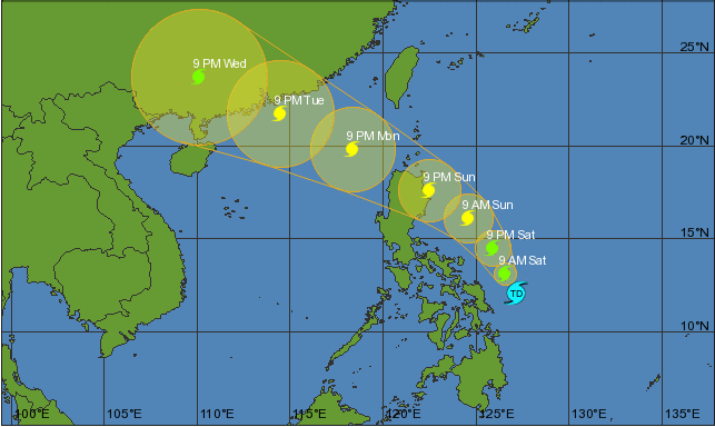
The storm's current trajectory places it on a path that could potentially impact several provinces in the northern and central regions of the Philippines. PAGASA's latest forecast models suggest that Carina will bring heavy rainfall and strong winds, posing a significant risk to affected areas. As a result, local authorities are on high alert, preparing for potential evacuations and implementing precautionary measures to ensure public safety.
Typhoon Carina's development has been closely monitored by meteorologists due to its rapid intensification and the potential threats it poses. The storm's maximum sustained winds have reached levels typical of typhoons, with gusts potentially exceeding 200 kilometers per hour. The combination of strong winds and heavy rainfall could lead to widespread flooding and landslides, particularly in vulnerable areas.
Emergency response teams across the affected regions are coordinating efforts to mitigate the impact of the typhoon. This includes preemptive evacuations in high-risk areas, the reinforcement of flood defenses, and the dissemination of timely information to the public. The Philippine National Disaster Risk Reduction and Management Council (NDRRMC) is actively involved in overseeing these preparations and ensuring that resources are allocated effectively.
Local weather stations are providing updates on the typhoon's progress and potential impacts. Communities in the projected path of Carina are advised to stay informed through official channels and adhere to safety recommendations. PAGASA continues to issue regular advisories, detailing the storm's movement and potential effects on different regions.
International meteorological agencies are also tracking Typhoon Carina's development, noting its significance in the broader context of global weather patterns. The storm's behavior and intensity are subject to ongoing analysis to understand better the factors contributing to its rapid intensification.
As Typhoon Carina progresses, the focus remains on minimizing its impact through coordinated response efforts and public awareness. Authorities are emphasizing the importance of preparedness and resilience in the face of such severe weather events. The situation is evolving, and updates will be provided as new information becomes available.
The typhoon is a reminder of the increasing frequency and intensity of severe weather events in the region, highlighting the need for continued vigilance and robust disaster management strategies. The impact of Typhoon Carina will likely be assessed thoroughly once it has moved out of the PAR, providing insights into the effectiveness of the response and areas for improvement in future preparedness efforts.
Topics
World